


Gauteng is having a very wet December. Flash floods, water damage, and people’s homes and infrastructure have been destroyed. But is this normal rain? How does it compare to December in previous years? Sarah Roffe, a climate researcher at the Agricultural Research Council, helps us unpack it.
Are we in a particularly bad rainy season?
I don’t think it’s easy to say if we are having a good or bad rainy season. Compared to previous years, the current rainy season has been characterized by above-normal rainfall totals in some areas and, based on forecasts by the South African Weather Service, it is likely that we will continue to experience above-normal rainfall until April 2023.
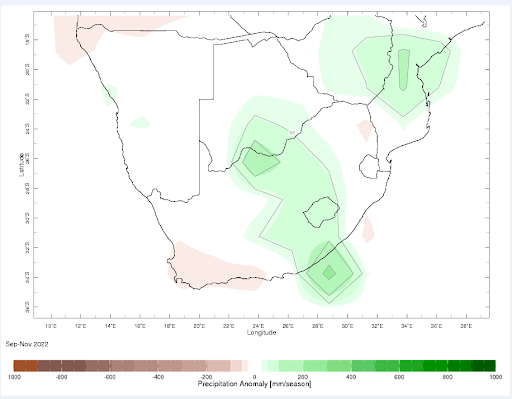
This can be seen as a good rainy season for agricultural and livestock production and for our water resources. But if we think about the distribution of rainfall and the fact that flooding is taking place (in Gauteng many areas have suffered and are experiencing flooding), then perhaps we could see the rainy season as a bad rainy season. So really the answer here depends on the perspective you take, and I think it’s best to consider both aspects.
Is the climate crisis changing our weather patterns?
In southern Africa, there are certainly detectable changes in our weather patterns. However, it can be difficult to say for sure if they are due to human-induced climate changes. The Sixth IPCC [Intergovernmental Panel on Climate Change] The assessment report has shown that there is a high level of confidence that temperature changes since the 1950s can be attributed to human-induced climate change. On the contrary, the report shows that there is little confidence that human activities have contributed to the changes in precipitation experienced in southern Africa since the 1950s.
Despite this, in recent decades scientists have reported changes in both precipitation and temperatures and their characteristics. In terms of temperatures, southern Africa is characterized by increasing trends, with the central regions experiencing the greatest warming trends, while the coastal regions have experienced lesser warming. Among the reported temperature trends, the most notable are those of extreme heat.
Recent research has shown that most regions of southern Africa are characterized by trends of increasing frequency and magnitude of heat extremes. Precipitation trends are more difficult to detect and are associated with much more uncertainty because precipitation can vary substantially from year to year, making it difficult to detect a trend statistically.
Since about the 1950s, many regions of southern Africa have experienced declining annual rainfall totals. While it is valuable to consider changes in annual rainfall totals, it is more relevant to consider how the distribution of rainfall events has changed and how rainfall has changed during the wet season.
If we consider those regions that predominantly experience summer rains (all of South Africa, excluding the West Coast and South-West Cape, as well as the South Coast) during the months of October-March/April, then it would be important to note that most of regions have experienced declining trends.
Despite this, many regions are characterized by increasing trends in the frequency and magnitude of individual rainfall events. But there is also a greater frequency and intensity of dry periods (consecutive dry days) that occur between rain events.
We are in a La Niña event. What is it, how long does it last and what are its effects on rainfall in southern Africa?
A La Niña event, or more specifically a phase, represents one of the phases of the El Niño Southern Oscillation (ENSO). ENSO is a natural cycle that occurs in the temperatures, winds, and clouds of the tropical Pacific Ocean. This cycle naturally oscillates between three phases, being El Niño, Neutral, and the current phase we are experiencing being La Niña. One of these phases usually lasts around a year, but this can extend up to three years, as we are seeing with the current La Niña phase.
We are currently in an unusual period of three years. This happened during 1973-1976 as well as 1998-2001, when La Niña extended to a duration similar to the current one.
During neutral phases, which represent “normal” conditions, natural tropical trade winds blow from east to west as is typical, accumulating warm water over the Indonesian island chain region (the western Pacific Ocean), allowing it to store colder water. off the coast of South America (the eastern Pacific Ocean). This naturally causes air to rise over the warmer water region and sink over the cooler water region creating a large horizontal circulation cell known as the Walker Circulation.
The La Niña phase is similar to the Neutral phase except that the trade winds blow stronger and the contrast between warm and cold water is greater, making the Walker Circulation even stronger. The El Niño phase can be viewed as the opposite of the Neutral and La Niña phases. Trade winds that flow from east to west blow much slower or even in a different direction, causing warm and cold water to pool for change. Each of these phases globally influences weather and climate, but their influence differs by region. The La Niña phase promotes wetter weather in southern Africa, but in the southern US it can promote drier conditions.
ENSO is important for us to understand, but the effects on southern Africa’s weather and climate are perhaps the most important to understand. Moisture for our summer rain often comes from the southwestern Indian Ocean from winds that flow generally east-west and carry moisture inland over southern Africa. These winds are generally strong during a La Niña phase, which is one of the main reasons why we often experience wetter than normal conditions during the summer rainy season.
Due to the change in winds during El Niño, we have less moisture flowing inland and often experience drier conditions as a result. It is important to note my mention of “often” because these typical conditions do not always occur during El Niño and La Niña phases.
Specifically considering the effects of La Niña over southern Africa, this is typically wetter and cooler than normal (around 30 year average) throughout the extended summer months of October through March/April, but its most Heavy rains are generally during the mid-summer months of November through February. Above-normal rainfall may sound like a good thing, but this can also cause flooding if the rain is concentrated in fewer, larger events.
Research has highlighted that flooding tends to be more frequent during the summers of the La Niña phase. This can, for example, damage the infrastructure. It can even be detrimental to life, as seen in the recent lives lost in the flooding in Johannesburg this month. It is also concerning that such heavier rainfall events could influence optimal planting timing and cause crop damage, ultimately influencing food security. Many other negative effects, such as waterborne diseases, can arise during flood events.
There is a shift to more La Niña conditions and this could be related to human induced warming.

When will El Niño come and there will be a drought?
Currently, there is limited certainty about when the next El Niño will occur. Several climate services track the current state of the ENSO and also provide forecasts on the state of the ENSO. Currently, forecasts suggest that an ongoing La Niña is expected to persist through early 2023. From February to April 2023, there is a 71% chance of ENSO-neutral conditions, meaning that the current La Niña is likely to break.
Normally ENSO-neutral conditions after La Niña should lead to El Niño, but this might not always be the case: during June and July 2021, La Niña broke, but starting in August, La Niña conditions Niña persisted again, and the length of time ENSO-neutral conditions will persist is also uncertain; this could be as short as one month and as long as three years.
Despite this, there is a certainty that an El Niño will occur in the future and with El Niño there is always the concern of drought, particularly during South Africa’s extended summer wet season from October to March/April.
This is because ENSO has a stronger effect on South African weather and weather during the summer (particularly from November to February), and El Niño generally brings drought, as well as warmer-than-normal conditions, which generally promotes drier conditions. However, it is always important to recognize that this is not always the case, and while most El Niños are generally associated with drought to varying degrees, the summer of 1997-98 represents an example of when El Niño did not cause drought.
Drought concerns are increasing across southern Africa as drought events significantly affect our food and water resources, and in line with changes in rainfall patterns in southern Africa, drought events are expected to be more devastating, which could lead to more “Days” possibilities. Zero” events like the one that nearly happened in Cape Town in 201517.
In 2015-16, El Niño caused dry conditions in which the capacity of the Vaal Dam fell to almost 20%, which would compromise the province.


